Client Success Story

Training an AI Solution for Geographic Data Mapping with Image Annotation for Water Features in Historical Maps

THE CLIENT

An Academic Institution

Our client is a well-known academic institution involved in studying and preserving natural water bodies. A key aspect of their research is analyzing historical data to understand changes in natural water bodies over time to uncover insights into environmental changes and help develop strategies for water conservation. To achieve this, the client was developing an AI/ML solution aimed at geographic data mapping. The solution required precise data input from annotated historical maps detailing water features such as rivers, lakes, and reservoirs.

PROJECT REQUIREMENTS

Accurate Waterbody Annotations for AI Training on Historical Maps

As the client was training an AI/ML solution for automated map analysis, The primary objective of the project was to provide high-quality, accurate annotations of water bodies in a large collection of historical map images. The client required-

  • Image annotation services for precisely annotating rivers, lakes, and other water bodies in 1,200+ historical map images.
  • Digital restoration to enhance faded and low-quality map images to facilitate clear and accurate annotation.
PROJECT CHALLENGES

Complexity in Annotating Diverse, Faded, and Complex Historical Maps

While the project had clear guidelines and requirements, our team faced several challenges due to the nature of the source material and the complexity of the project including:

  • Diverse Cartographic Styles

    The historic maps provided by clients had varied cartographic styles. Some maps showed artistic interpretations of water bodies, while others were more technical, which complicated the annotation process.

  • Old, Faded and Degraded Maps

    The image dataset received from the client had faded details due to ageing, discoloration, or wear, which made it challenging to identify water bodies accurately.

  • Complex Water Systems

    Some maps contained intricate water systems with interconnected rivers, lakes, and coastal features, requiring careful attention to detail during annotation.

  • Need for Manual Annotation

    Despite access to industry-leading annotation tools, we were required to perform manual annotation and verify images annotated by tool due to unclear images as inaccuracies would negatively affect the AI model's training process.

SOLUTIONS OFFERED

Water Body Annotation and Digital Restoration of Historical Maps

Our team of three dedicated image annotators and a photo enhancement expert used a strategic combination of technical solutions, manual expertise, and digital enhancement techniques to overcome these challenges and meet the client's objectives:

1

Customized Annotation Guidelines

We developed a detailed set of annotation guidelines specific to historical water feature mapping. These guidelines included instructions on handling different cartographic styles and unclear map images.

2

Digital Restoration of Map Images

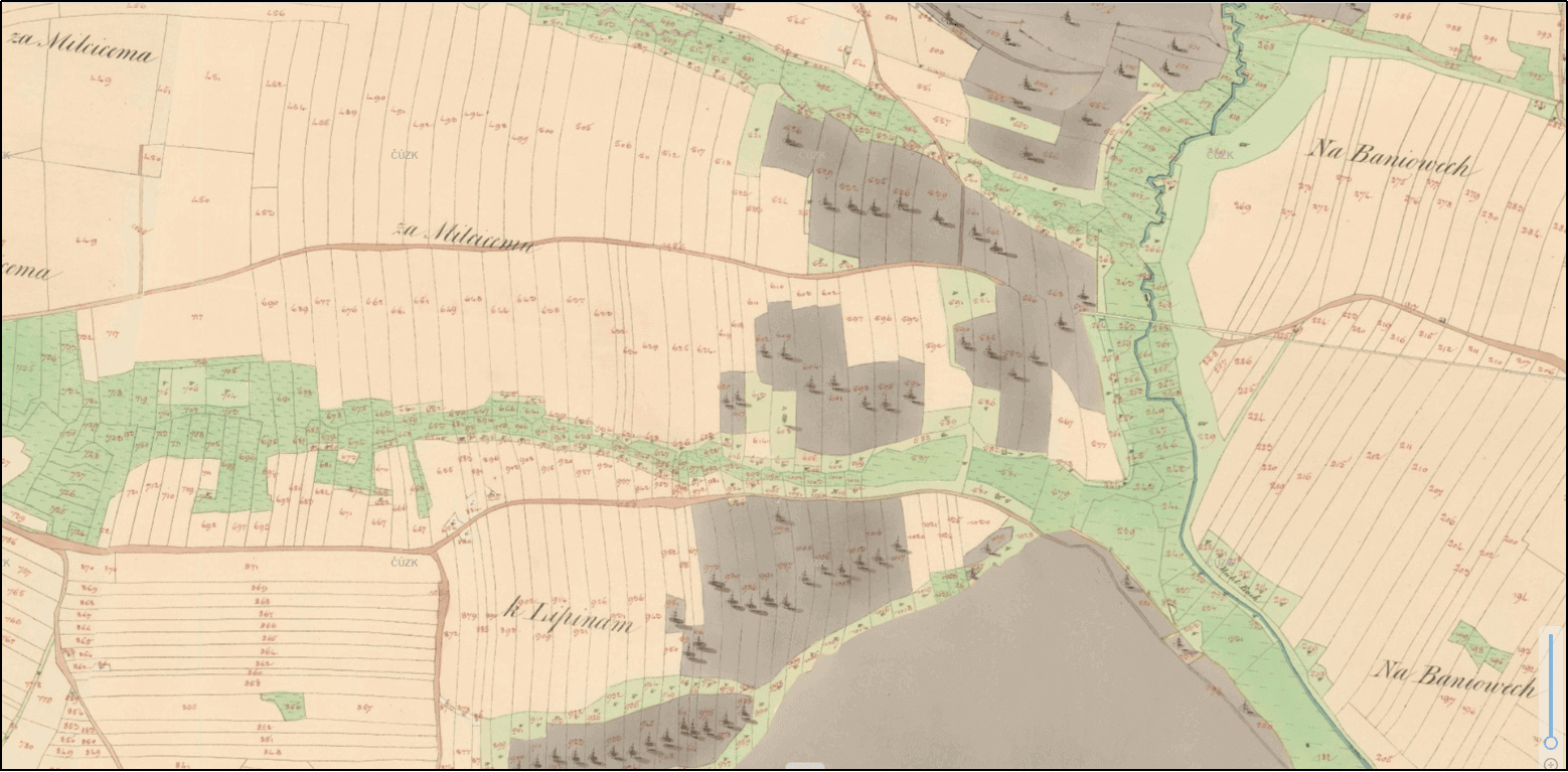
Our photo editing expert used advanced digital restoration techniques to enhance the clarity of faded or degraded maps. This process involved adjusting contrast and sharpening edges to bring out subtle details for accurate annotation.

3

Image Annotation on a CVAT

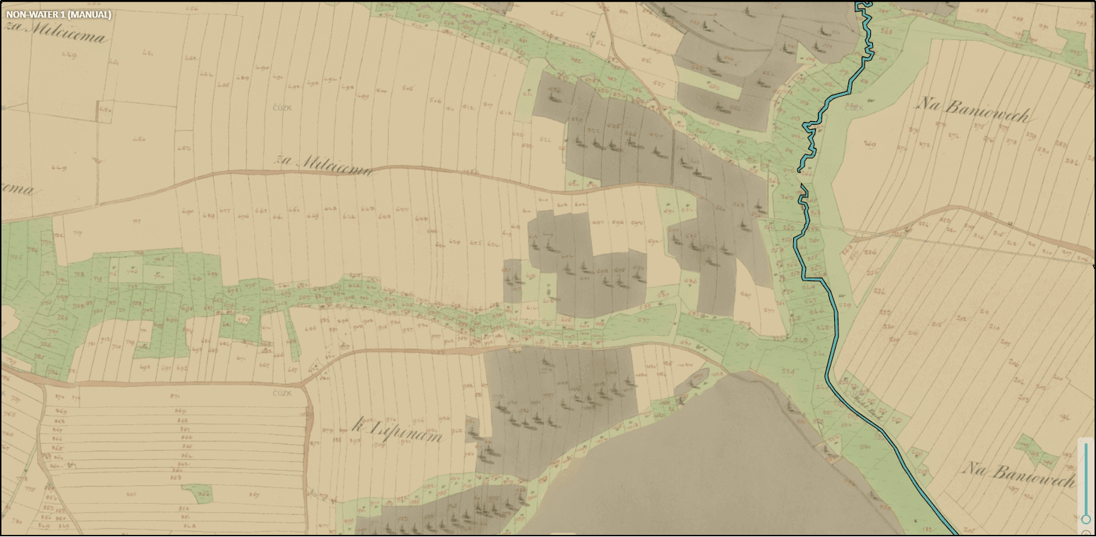
We used a locally hosted CVAT (Computer Vision Annotation Tool) that was secure, customizable, and allowed precise polygonal masking. This tool enabled our team to carefully outline the contours of water features like rivers, lakes, and streams ensuring accuracy in each annotation.

4

Custom CVAT Enhancements

We implemented custom scripts within the CVAT environment to assist with common annotation tasks specific to water body identification. These enhancements included automatic detection of potential water features based on color and pattern recognition, which annotators could then verify and refine.

water bodies annotation
Water Bodies Annotation

Project Outcomes

A High-Quality Annotated Dataset

A precisely annotated dataset of 1200 historical maps provided a strong foundation for AI/ML model development and research.

40% Improvement in the Object Detection Accuracy

The client's model became far more proficient at recognizing and categorizing different water bodies across the historical maps

CONTACT US

Train your AI/ML Models with 100% Reliable Datasets

Leverage our data annotation services and ensure precise, high-quality image annotations for optimal model performance. To know more about our services, get a free trial, or discuss your project, write to us at info@suntecindia.com